

Contents
Shipwrecks & Artificial Reef Fishing
The California Department of Fish and Game has been building and maintaining artificial reefs since the 1960s and their efforts have been nothing short of fantasic in developing havens for game fish. Add to this, quite a number of ships sunk both accidentally and intentionally, and you have an abundance of excellent fishing holes, some well known and heavily fished and some others very rarely fished. Whenever I’m out fishing and the usual spots just aren’t producing, the first thing I do is call up the waypoint for the nearest wreck or artificial reef and set a course. I’m very rarely disappointed.
Submerged structure serves as a hideout for many small species of marine animals serve as prey for small bait fish. Wherever bait fish are, of course, game fish won’t be far behind. Down in the wrecks and reefs, structure loving fish like Calico Bass, Sheepshead, Whitefish, Halfmoon, Blacksmith, Shallow water Rockfish, Ling Cod (seasonally) and many others. In the flats around the wrecks and reefs, you find many flats fish including Sand Bass, Sculpin, and Halibut. In addition surface fish like Yellowtail, Barracuda and Bonito also are attracted to the abundance of food around wrecks.
Map of California Shipwrecks and Artificial Reefs with GPS Coordinates
Following is a chart of the artificial reefs and main fishable shipwrecks along the Southern California coastline:
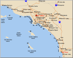
The following table shows the approximate center of the main wreck and artificial reef fishing spots. Many of these cover fairly wide areas, and often the best fishing areas may be entirely different from one day to the next. This means that some trial and error may be needed to find a productive parts of the reefs on any given day.
| No. | Name | Approx Size | Coordinates |
| 1 | International Reef | 75 Acres | 32D 32.40’N. x 117D 14.70W |
| 2 | Mission Beach Reef | 173 Acres | 32D 46.23’N. x 117D 16.30’W |
| 3 | Pacific Beach Reef | 109 Acres | 32° 47.58’N. x 117° 16.57’W |
| 4 | Torrey Pines Reef #1 | 500 ft. | 32D 53.20’N. x 117D 50.83’W |
| 5 | Torrey Pines Reef #2 | 1 Acre | 32D 53.58’N. x 117D 15.58’W |
| 6 | Carlsbad Artificial Reef | 6 Acres | 33D 05.00’N. x 117D 19.15’W |
| 7 | Oceanside Artificial Reef #1 | 4 Acres | 33D 10.95’N. x 117D 25.00’W |
| 8 | Oceanside Artificial Reef #2 | 256 Acres | 33D 12.58’N. x 117D 25.80’W |
| 9 | Pendelton Artificial Reef | 3.5 Acres | 34D 19.50’N. x 117D 31.70’W |
| 10 | Newport Beach Artificial Reef | 8 Acres | 36D 16.22’N. x 117D 57.82’W |
| 11 | Huntington Beach Art. Reef #1 | 3 Acres | 33D 37.45’N. x 118D 00.07’W |
| Huntington Beach Art. Reef #2 | 3 Acres | 33D 37.28’N. x 117D 59.85’W | |
| Huntington Beach Art. Reef #3 | 3 Acres | 33D 37.15’N. x 117D 59.28’W | |
| Huntington Beach Art. Reef #4 | 3 Acres | 33D 36.85’N. x 117D 58.82’W | |
| 12 | Bolsa Chica Artificial Reef | 220 Acres | 33D 39.05’N. x 118D 00.06’W |
| 13 | Gambling Ship Shipwreck | 300 ft | 33D 41.49’N. x 118D 08.75’W |
| 14 | Georgia Straights Shipwreck | 200 ft | 33D 41.34’N. x 118D 12.49’W |
| 15 | Minesweeper Shipwreck | 250 ft | 33D 41.60’N. x 118D 19.45’W |
| 16 | Avalon Shipwreck | 350 ft | 33D 47.28’N. x 118D 25.62’W |
| 17 | Palawan Shipwreck | 450 ft | 33D 49.42’N. x 118D 24.88’W |
| 18 | Redondo Beach Artificial Reef | 1.5 Acres | 33D 50.23’N. x 118D 24.53’W |
| 19 | Hermosa Beach Artificial Reef | 0.5 Acres | 33D 51.22’N. x 118D 24.80’W |
| 20 | Marina Del Rey Art. Reef #1 | 3.5 Acres | 33D 57.90’N. x 118D 29.17’W |
| Marina Del Rey Art. Reef #2 | 7 Acres | 33D 58.10’N. x 118D 29.18’W | |
| 21 | Star of Scotland Shipwreck | 180 ft | 33D 59.52’N. x 118D 31.27’W |
| 22 | Santa Monica Artificial Reef | 0.5 Acres | 34D 00.57’N. x 118D 31.78’W |
| 23 | Santa Monica Bay Art. Reef | 256 Acres | 34D 00.78’N. x 118D 32.55’W |
| 24 | Topanga Artificial Reef | 13 Acres | 34D 01.63’N. x 118D 31.95’W |
| 25 | Malibu Artificial Reef | 0.5 Acres | 34D 01.49’N. x 118D 39.03’W |
| 26 | Pitas Point Artificial Reef | 1 Acre | 34D 18.13’N. x 118D 22.10’W |
| 27 | Winfield Scott Shipwreck * | 500 ft. | 34D 00.57’N x 119D 23.25’W |
| 28 | Diosa Del Mar Shipwreck * | 90 ft. | 33° 27.60’N x 118D 29.10’W |
| 29 | John Butler Shipwreck (In NW Harbor) | 300 ft. | 33D 02.17’N x 118D 34.92’W |
| 30 | Gregory (Indoctrinator) Shipwreck * | 300 ft. | 32D 53.08’N x 118D 31.08’W |
| * WARNING – Exposed or Tidal Rocks & Shoal Water – Use Extreme Caution | |||
| IMPORTANT NOTE! The GPS coordinates indicated here are for informational purposes only. They represent the author’s belief of the correct approximate locations of various fishing areas. These numbers should NOT be used for navigation. No guarantee of the accuracy of this information is expressed nor implied. ALWAYS use proper navigation methods and techniques when operating a boat anywhere in coastal or offshore conditions. | |||
Best Times of Year for California Shipwerck and Artificial Reef Fishing
Following is a chart of the commonly caught wreck and reef fish, along with the time of year you’re likely to catch them, and the preferred depths. Be SURE to check with the California Department of Fish and Game for the latest regulations on closed seasons, closed areas, minimum size and maximum bag limits on any fish you plan to take. The regulations change often. This information is available on-line on the Cal DF&G; website at: http://www.dfg.ca.gov/
| Fish | Best Fishing | Possible | Habitat | Best Bait |
| Calico Bass | May-Oct | Year Round | Reef | Live Bait |
| Sheepshead | Nov-Mar | Year Round | Reef | Shrimp |
| Whitefish | Nov-Mar | Year Round | Reef | Cut Squid |
| Halfmoons | Nov-Mar | Year Round | Reef | Cut Squid |
| Rockfish | Nov-Mar | Year Round | Reef | Cut Squid |
| Halibut | Nov-Apr | Year Round | Flats | Live Bait |
| Sand Bass | Mar-Aug | Year Round | Flats | Live Bait |
| Sculpin | Nov-Jun | Year Round | Flats | Cut Squid |
| Barracuda | Jun-Sep | Mar-Nov | Surface to Midwater | Lures |
| Yellowtail | Jun-Sep | Year Round | Surface to Midwater | Live Bait |
The Best Techniques to Fish the California Shipwrecks and Artificial Reefs
Shipwrecks and artificial reefs are usually fished by anchoring up so that the boat settles over the target. Then baited hooks are sent down into the obstructions. These are generally spotted using a good video fish finder. Usually the wrecks or reefs appear as sudden changes in bottom shape when moving across flat bottomed areas.
The preferred rig in reefs and wrecks areas is the Carolina rig, that is, a 3/4 to 1-1/2 oz sliding egg sinker held 24-36″ above the bait hook with a split shot, swivel, or “Carolina Keeper” plastic bead. In deeper water, a reverse dropper loop is often the hot ticket. Attach a 2-4 oz torpedo sinker on a dropper loop 24-36″ above the bait hook, and send her down baited with a live bait or piece of cut squid. If using live bait, keep changing the bait so it’s lively for best results. Also nose hooking a bait is usually better than gill hooking when fishing the flats. the bait swim more naturally and seem to survive better.
Artificial lures are also useful in the reefs. When Sand Bass and Barracuda are around, a hard metal jig, allowed to sink then yoyo’ed up and down makes an enticing target. Calicos will also hit a hard jig. Rubber swim baits fished bare, or sweetened with a thin strip of cut squid can really knock dead the Bass, Halibut or sometimes Yellowtail, when other techniques aren’t working.